Current research project (2019-2022)
senseBox:pro
The senseBox and openSenseMap are already established open photonics tools in the context of environmental monitoring for citizen science and education. In the senseBox Pro project, we aim to expand the target groups of the senseBox and openSenseMap. Through further modularization, self-sufficiency and miniaturization, the seneBox will be made more usable especially for companies and public authorities. The openSenseMap taps into this target group primarily through a standardization and digital mapping of environmental phenomena and photonic sensors in an open extensible SensorWiki. A social network connected to the openSensMap will provide more opportunities for all user groups to understand photonic environmental data, communicate about it and turn it into innovations. A learning environment will provide the basic skills needed for this, such as programming and physics principles, and facilitate the transfer to innovation.
Partners
The senseBox:pro project is a joint project of Reedu GmbH & Co. KG and the Institute for Geoinformatics of the Westfälische Wilhelms-Universität Münster.
re:edu is a start-up and spin-off from the Institute of Geoinformatics. Since 2018, re:edu is the producer of the senseBox and offers a wide range of services around the senseBox and the fields of Digital Education, Citizen Science and Smart Cities.
The Institute for Geoinformatics at the Westfälische Wilhelms-Universität Münster is one of the world's leading institutes in research and teaching in the context of geoinformatics. In the senseBox Pro project, the Spatial Intelligence Lab of Prof. Dr. Angela Schwering is partgit.
Researchgoals
Hardware
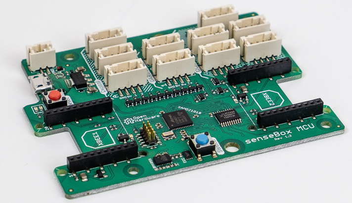
Within the scope of the senseBox Photonik project, the senseBox MCU was successfully developed and established in the field of Citizen Science as well as in education. Miniaturization and self-sufficiency are intended to make the senseBox MCU and its devices based on it more independent of a power and data connection in order to reach new groups of users.
openSenseMap
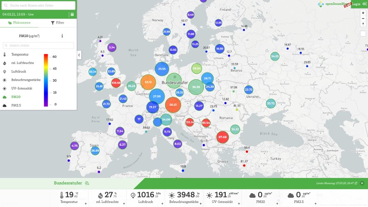
The openSenseMap aims to move from a citizen network platform to a central portal for open photonic sensor data. The project will explore the possibilities of scaling the openSenseMap towards a Big Data portal. This will make the data available through the openSenseMap and its interfaces easier to evaluate in terms of quality and meaning, and easier to use. Thus, they can serve as the basis for new products.
Learning environment
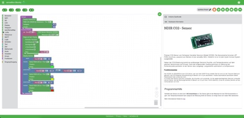
Through an additional learning platform integrated into the openSenseMap, the basic technical knowledge (photonics, electronics, programming) is to be conveyed and the breadth of the application possibilities of the senseBox is to be demonstrated. In this way, the transfer of scientific knowledge, e.g. to young companies in the fields of Internet of Things, sensor technology, but also digital education, can succeed and flow into new products.
Funding
With the funding measure 'Open Photonik Pro', the Federal Ministry of Education and Research (BMBF) is pursuing the goal of enabling new forms of collaboration between science and industry with the maker and start-up scene. The aim is to open up additional innovation paths and potential. At the same time, innovation cycles are to be significantly shortened and the networking of these groups sustainably improved.
more about the fundingSenseBox Photonics and OpenSenseMap: 2016-2019
The SenseBox project aims to enable citizens to participate in the scientific investigation of current, socially relevant issues using photonics technologies. Citizens will be provided with inexpensive sensor stations and the know-how to perform measurements on relevant local issues. For this purpose, the project develops the "SenseBox Photonik": a do-it-yourself kit for a low-cost sensor station with optical sensors for measuring brightness, infrared, UV light, a photonic fine dust sensor and a camera. The sensor stations are networked with each other and the recorded measurement series are made publicly available via the web-based platform OpenSenseMap, so that citizens can analyze their own problems.
Publications
-
Erdmann, Felix and Shum, Artur Kim and Schnell, Johannes and Bartoschek, Thomas and Kraatz,Julia and Gräler, Benedikt (2026): Open-Source-Tools und Citizen Science für urbane Mobilitätsdaten
-
Witte, Verena and Pesch, Mario and Bartoschek, Thomas (2025): Physical Computing im MINT-Unterricht am Beispiel der senseBox:edu S2
-
Bruch, Frederick and Bartoschek, Thomas and Karic, Benjamin and Pesch, Mario and Schwering, Angela and Pfeil, Mathias (2025): Reviewing 10 years of openSenseMap - the open environmental data platform for (GI)Science, Education and Participation
- ... go to the complete list of publications